Texas Trinity River
The headwaters of the Trinity River in Texas are sourced from four major forks in north Texas. Then their waters flow all the way south to outlet at Galveston Bay.
When the four merge some miles south of Dallas, other significant tributaries contribute to its flow.
With purchases made via links on our site, we may earn a small commission at no extra cost to you. Details at our Advertising Policy.
Lets flow along with these waters to see what interests us along the way!
Texas Trinity River Forks
The Trinity River's East Fork is sourced from several creeks in areas around McKinney, Anna, Trenton & Tom Bean in Texas. These feed into Lavon Lake.

Not much further south, a short jog of the East Fork takes you to Lake Ray Hubbard.

Flowing south thereafter, eventually reaching the confluence with what's the final combined flow of the Trinity forks.
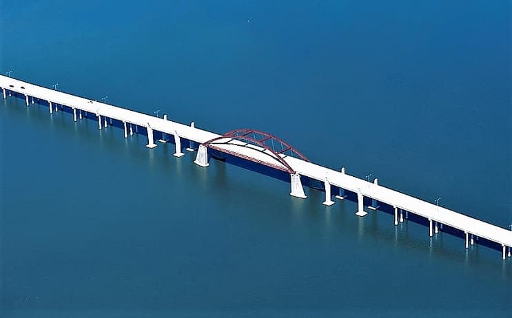
An outstanding place below this is Lake Livingston. East of Huntsville, Northeast of Houston.

The Elm Fork's headwaters arise in eastern Montague County. When finally joining with the Trinity River, you've gone 85 miles.1
The headwaters are northwest of County Hwy.59/State Hwy.82 junction, west of St. Jo TX. Flowing west of town, then south until waters impound for Soil Conservation Service Site-5 Reservoir.
It meanders southeasterly until finally nearing the Gainesville area, where it jogs southward.
East of Valley View waters widen out from the northeastern impoundment, with the Lake Ray Roberts Dam forming...
Ray Roberts Lake - Several choices for visiting via units of Ray Roberts Lake State Park. Plus a State Rec Area lakeside.
- The lake waters flow out of the dam, winding southward.

Trinity River's Elm Fork winds its way to & through Greenbelt Corridor Park in Denton TX. Then Clear Creek Natural Heritage Center.
A new shoreline begins here with more impounded waters...
Lewisville Lake - Abundance of parks onshore. Like Westlake Park & Hidden Cove Park. The lake's dam is in Lewisville, a northern suburb of Dallas.
The Elm Fork exits the dam into LLELA Nature Preserve. Now flowing through urban areas, adjacent to several golf courses.
North of Irving, Trinity River's Elm Fork borders trail parks like Sam Houston, Spring & Bird's Fort.
As it enters the Dallas outskirts it confluences with the Trinity River. As their waters combine, they enter the Trinity River Corridor, & become the Trinity River.
The West Fork's headwaters are generally northwest of Jacksboro to east of Olney TX. Numerous springs, ponds & streams here direct waters into West Fork.
- A USGS monitoring gauge west of Prideaux Rd. (west of 281 junction with 187) shows upstream flows come through averaging 1.5 cu/ft sec. However there were times no flow was measured.2
 Gauging West Fork Headwater Flows
From the gauge, the fork's trajectory generally undulates southeastward. Southwest of Chico, it begins widening out as it forms a lake...
- Lake Bridgeport - West of the same-named town. Numerous campsites are on its shores. Excellent fishing for crappie & striped bass.3 City owned marina at the lake's south end. Dam is on the lake's east side.
Catching Crappie at Lake Bridgeport
Now the West Fork outflow continues east, then takes a jag generally southward. Finally widening out south of Aurora, forming another lake...
Eagle Mountain Lake - Multiple marinas lakeside. Also parks like Eagle Mountain Park, Pelican Park & Shady Grove Park. Swimming Beaches, too. The fork exits at the dam adjacent to Carter Slough.

Then entering gorgeous Fort Worth Nature Center & Refuge.
- Which has wetlands with a boardwalk
- Access to a wonderful island (especially if you love birding!)
- Historical ruins
- Plus the transition from the river's West Fork to another lake.


Lake Worth is northwest of Fort Worth. Public access from several city parks along its shore. What's really nice is the Trinity River Paddling Trail.
- Historically, there's even a report of a local "monster" that maybe (:-o) roamed the area!
Lake Worth Monster !
Do You Believe It??
Tell Us:
The West Fork exits the Lake Worth at the dam just south of Marion Sansom Park.
Meandering a bit further east & south until the Clear Fork merges, becoming part of the West Fork.
The water flows through Fort Worth, forming borders to multiple city parks. Then south of Irving, approaching Dallas is the confluence with Elm Fork as they form Texas's Trinity River.
Clear Fork - Sourced north of Weatherford from springs & small creeks like Gourdneck & Beene Branch, in farming areas.
Flowing under County Rd.51, it continues south.
Entering the town's lake at an area with lots of lily-pads.
But what's really unique before entering the major part of the lake:
- Weatherford Lake Park. Its floating boardwalk:
Lake Weatherford - A roadway encircles the lake. There's a marina. Plus lakeside Disc Golf nearby the lake's impoundment dam at the south end.
Where the Clear Fork's waters flow out.
This fork of the Trinity River winds southward, until widening out SW of Fort Worth as it forms another lake...
Benbrook Lake - At the edge of suburbia, good place for access is North Holiday Park. Swimming beach is rocky, but nice for kids - just bring water shoes.
There's also a lakeside marina.
A favorite park is at the south end: Mustang. The dam is at the north end, where the Clear Fork outlets through Pecan Valley Park.
The Clear Fork now flows generally northward. Under I-30 Exit 12, and into Fort Worth, alongside Trinity Park.
After going under County Hwy.199 the Clear Fork merges with Trinity's West Fork, giving up its name to the West's.
Soon it begins twists & turns generally eastward.
Through Arlington Texas.
Johnson Creek is a major tributary out of the West, when reaching Grand Prairie.
In Irving TX, the West Fork joins the Elm Fork.
It's now one, as the Texas Trinity River starts flowing altogether in Dallas's Trinity River Corridor. Continuing on midway between Ferris & Combine, TX. It's out of the more urban Dallas areas, through farmlands.
Then South of Combine it meets its final confluence with a fork: The East Fork Trinity River. All the Forks join to form the Trinity River.
Heading southeasterly toward its outlet.
Along the way, there are many adjacent oxbow lakes. Plus the Trinity River picks up more confluent from other influential waterways. We'll see what they are!
Wildcat Creek is a strong stream merging from the East at Malakoff Texas. Not far south, boat ramp access is adjacent to U.S.Hwy.287.
An interesting confluence arrives from the west...
- Two streams, the Saline & Gaston Branches join to form a good-sized lake.
- An outlet on the east shortly forms a small lake.
- An out-stream soon flows into the largest lake, Blue Lake. Which has an outflow stream on the north end, soon going into Texas's Trinity River.
- All within Big Lake Bottom Wildlife Management Area, Streetman TX. North of Oakwood. It's primarily a hunting facility.
- Find a nice oxbow east of Oakwood: Glaze Lake. County Hwy.241 runs along its western shore.
Upper Keechi Creek flows in from the west. With Haley Creek as its own tributary.
Soon Big Elkhart Creek merges strongly from the east, adjacent to a large oxbow lake.
A little more south, just off State Hwy.7 is Lock and Dam Marina. A place to experience the river, with fishing, camping & cabins. They have a Facebook Page for info.
Klapps Creek merges into Lower Keechi Creek - a west-side tributary in the Centerville area. When soon Boggy Creek flows in.
Bedias Creek, a section which is Moten Lake, is another west-side tributary. Around Midway Texas.
North of Riverside, many wetlands make up the merge as Harmon Creek flows into the Trinity.
Livingston Reservoir is part of this watery area, where the Trinity River begins widening its banks. Thomas Lake is adjacent, sharing waters.
When soon Texas's Trinity River makes up the waters of Lake Livingston. Plenty of parklands & camping on its shores. The state park, a little northeast of Lake Livingston Dam, where Texas Trinity River waters continue on.

Winding southward, with sooo many adjacent oxbow lakes - some named, some not. Flowing alongside & near other parks and wildlife refuges.
Finally reaching South Texas, to an area where lots of waterways intertwine.
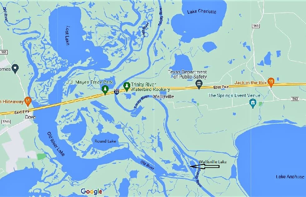
Pickett's Bayou joins The Cutoff which merges with the Trinity River. The Cutoff also connects to Lost River, which soon forms Lost Lake.
At Lost Lake's outlet, is the Old River confluence.
That widens out to form Old River Lake. Which influences Round Lake just before becoming Old River again as it meets its confluence with the Texas Trinity River.
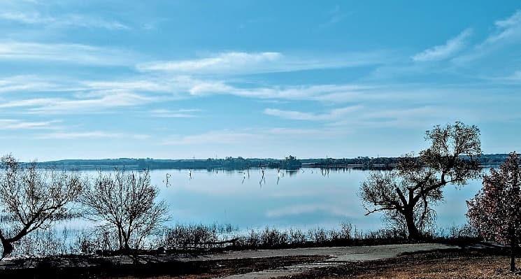
Meanwhile the Trinity flows under I-10, merged with a small stream out of Lake Anahuac. Then adjacent is a small Wallisville Lake.
Got that??
Maybe it's easier just to show you!
Finally south of Lake Anahuac, Texas's Trinity River flows west of the town of Anahuac.
While gently flowing southwestward it's alongside Fort Anahuac Park. There's dry camping, plus playgrounds, boat ramp & Texian history.4
Then on to its outlet into Trinity Bay, & on to Galveston Bay.
Other Pages For You:
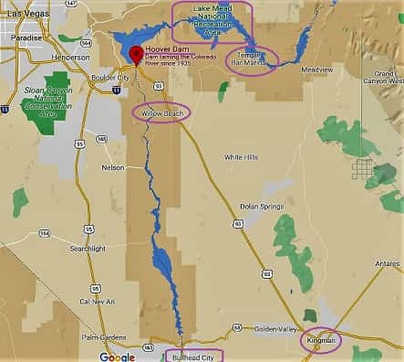
Lake Mead Arizona - We Get You There!
Lake Mead National Recreation Area on the Arizona side of the lake has some water areas left. Boat rentals, fishing, best camping spots + see Hoover Dam
Rivers and Lakes in California - We Take You!
Rivers and Lakes in California range from wild, scenic, recreational & pristine to endangered and need of our help. Many create lakes for our usage.
Arizona Rivers - Take This Virtual Trip
Arizona rivers are found in all corners of AZ! From mountains to desert. Is that surprising? We give you notable facts on their routes & their flowing ability.


See References For Texas Trinity River>
Some Directional Information on This Page May be sourced from Map data ©Google
If You're Enjoying This - Please Pay it Forward
Send It/Share It

We're From Arizona & We Know Our Southwestern Home
We Love Helping Others Appreciate It Too!
Supporting Local Businesses Throughout the Southwestern USA
Privacy Policy | Terms/Conditions/CC Licenses | Advertising Disclosure | Contact Us
© SWlakesUSA.com: 2021-2022 - A Production of Picture Rocks Networking LLC | All Rights Reserved
As an Amazon Affiliate we earn from qualifying purchases.
WE DO NOT SELL ANY PERSONAL INFORMATION FROM THIS WEBSITE
This site is protected under U.S. and International copyright laws. Do Not Copy - No use is permitted without permission.


What Do You Say? Comments
We'd like to hear from you. Have a comment or question? Say it here: